What Is a Commercial Drone?
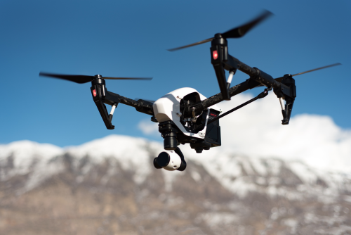
Drones have quickly evolved from weekend hobbies and casual photography tools into essential instruments for modern industries. Today, businesses across the globe use flying robots to survey land, inspect towering structures, monitor farm health, map remote terrain, and speed up complex operations. At the center of this shift is the commercial drone. A commercial drone is an unmanned aerial vehicle built or deployed primarily for professional, business, or industrial work rather than personal recreation. While a hobby drone might capture vacation photos or weekend park flights, a commercial drone serves as an active working tool for businesses, contractors, researchers, and public service agencies. Companies use these systems to collect reliable aerial data, inspect hard-to-reach places safely, and improve overall operational efficiency. The primary difference between commercial and hobby drones lies in their build quality, payload flexibility, sensor precision, data security, and intended business purpose. Common examples include heavy-duty quadcopters mapping large agricultural fields, thermal-imaging drones inspecting solar panel arrays, and zoom-equipped systems checking high-tension power lines.
Commercial Drone vs Consumer Drone
| Feature | Commercial Drone | Consumer Drone |
| Main purpose | Professional work, data collection, and industrial inspection | Personal photography, recreation, and hobby flying |
| Typical users | Surveyors, farmers, inspectors, enterprise teams, and businesses | Hobbyists, content creators, and casual flyers |
| Camera options | Interchangeable, thermal, multispectral, LiDAR, or high-zoom | Fixed high-resolution RGB camera |
| Flight features | Advanced waypoint navigation, automated grid flying, and RTK GPS | Basic Return-to-Home, point-of-interest, and quick shots |
| Sensors | Advanced multi-directional obstacle sensing and terrain following | Basic forward/backward or omnidirectional obstacle avoidance |
| Durability | Ruggedized builds designed for dust, light rain, and tough job sites | Lightweight frames optimized for portability and battery life |
| Cost | Higher investment reflecting enterprise software and specialized sensors | Budget-friendly pricing accessible to general consumers |
| Professional applications | Infrastructure mapping, crop analytics, search and rescue, and volumetric surveys | Personal vlogs, family travel videos, and recreational hobby clips |
How Does a Commercial Drone Work?
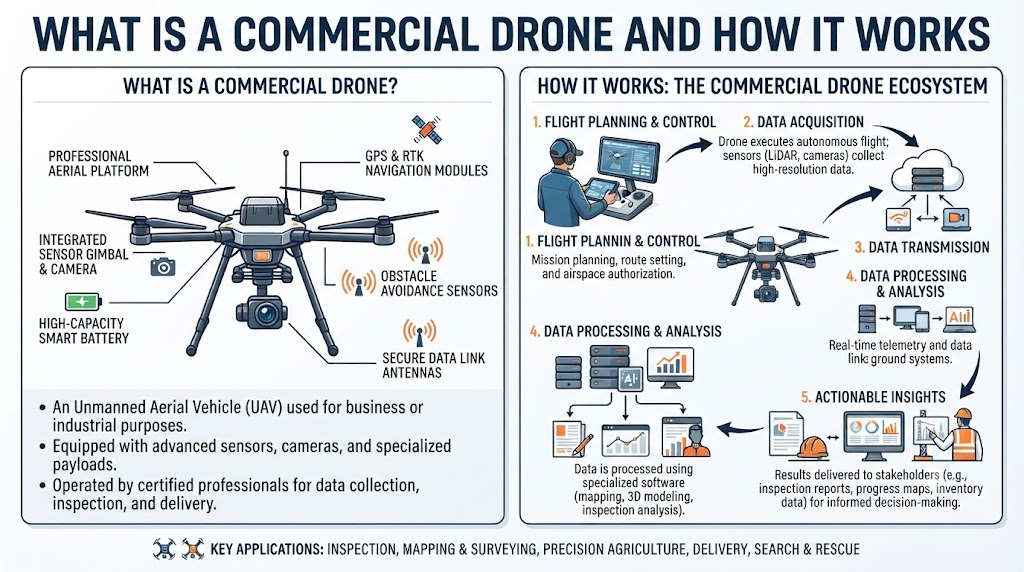
Understanding how a commercial drone operates helps businesses integrate the technology smoothly into their daily workflows. The process involves a structured chain of electronic, mechanical, and software actions:
- The operator gives a command: The pilot uses a handheld remote controller or a pre-programmed flight app on a tablet to issue instructions.
- The flight controller receives the command: The onboard computer processes the pilot’s input or automated flight plan.
- Motors and propellers create lift: Electronic speed controllers adjust power to the motors, spinning the propellers to lift the aircraft off the ground.
- Sensors track movement and position: Gyroscopes and accelerometers constantly measure tilt, speed, and orientation.
- GPS helps with location and navigation: Satellite signals verify the exact geographic coordinates and maintain steady flight paths.
- The drone adjusts its movement: The flight controller makes thousands of tiny motor adjustments every second to keep the drone steady against wind and inertia.
- The camera or payload performs the required task: The onboard sensor captures photos, records video, maps terrain, or scans thermal signatures.
- Data is sent or stored: Captured information is saved to an onboard memory card or transmitted in real time to the ground station for analysis.
Main Parts of a Commercial Drone
Flight Controller
The flight controller acts as the brain of the aircraft. It processes data from every onboard sensor, interprets pilot commands, and manages motor speeds to ensure safe, stable flight.
Motors
High-efficiency brushless motors provide the raw rotational power needed to turn the propellers. Commercial drones rely on robust motors built to handle long hours of demanding operational stress.
Propellers
Propellers turn motor rotation into aerodynamic lift. Their shape, pitch, and material directly impact battery efficiency, wind resistance, and overall flight stability.
Battery
High-capacity lithium polymer or smart batteries supply the electrical energy required to power the motors, flight computer, sensors, and payload cameras during flight missions.
GPS and Navigation System
Global Positioning Systems connect with multiple satellite constellations to pinpoint the drone’s exact location, allowing for precise route planning, automated grid flying, and reliable position holding.
Sensors
- Obstacle sensors: Use vision or infrared technology to detect trees, walls, or wires and help prevent collisions.
- Position sensors: Help the drone maintain its exact hover point indoors or close to the ground where GPS signals might fail.
- Altitude sensors: Measure height above ground level to ensure safe and consistent vertical positioning.
- IMU sensors: Measure acceleration and rotational forces to keep the aircraft oriented correctly in three-dimensional space.
Camera and Payload
A payload refers to any extra equipment or sensor carried by the drone to accomplish a specific job. Examples include standard RGB cameras, thermal imaging units, LiDAR scanners, mapping sensors, and specialized industrial inspection tools.
How Commercial Drones Stay Stable in the Air
Maintaining steady flight in changing weather conditions is vital for capturing sharp data. Commercial drones achieve stability through a continuous loop of automated corrections.
The onboard flight controller receives constant updates from gyroscopes, which measure rotation, and accelerometers, which track linear movement. If a sudden gust of wind tilts the aircraft, the flight controller instantly detects the shift and commands individual motors to speed up or slow down.
Position sensors and GPS support this stabilization process by locking the drone’s geographic coordinates in place when the pilot releases the controls. By making micro-adjustments thousands of times per second, the aircraft stays level and steady without requiring constant manual corrections from the operator.
How Commercial Drone Cameras Work
Different business tasks require different visual capabilities. Commercial drones use a variety of specialized camera systems to capture actionable data:
- Standard cameras: Capture clear everyday photos and videos for general site overviews and progress tracking.
- High-resolution cameras: Provide sharp detail needed for detailed mapping, photogrammetry, and close-up visual inspections.
- Thermal cameras: Detect heat signatures, helping technicians spot electrical faults, insulation gaps, and overheating machinery.
- Zoom cameras: Allow operators to inspect tall towers, bridges, and wind turbines from a safe distance without flying dangerously close.
- Multispectral cameras: Capture invisible light wavelengths, such as near-infrared, to help farmers analyze crop health and plant stress.
For instance, a construction team might rely on high-resolution cameras for daily site mapping, while an agricultural enterprise uses multispectral imaging to monitor irrigation efficiency across large fields.
How GPS Helps Commercial Drones
Global Positioning Systems form the backbone of automated commercial drone operations. GPS technology enables accurate location tracking, allowing operators to monitor exact flight paths on a ground station screen.
It powers precise navigation, position holding against strong winds, and pre-planned waypoint routes for automated mapping missions. GPS also drives safety features like Return-to-Home, which guides the aircraft back to its exact takeoff point if battery levels run low or signal connection drops.
While GPS is essential for outdoor missions, modern commercial drones also use visual positioning systems and local vision sensors to navigate safely when satellite signals are weak or blocked.
Common Uses of Commercial Drones
Agriculture
Farmers use drones to monitor crop health, assess plant growth, track irrigation patterns, and plan targeted fertilizer or pesticide applications across large acreage.
Construction
Construction teams use aerial tools to support site surveys, track daily project progress, create 3D site models, and inspect difficult-to-reach scaffolding or roofing.
Land Surveying and Mapping
Surveyors capture high-accuracy aerial data to generate topographic maps, elevation models, and precise volumetric measurements for civil engineering projects.
Infrastructure Inspection
Drones inspect vital public and private assets safely, including bridges, cellular towers, power transmission lines, solar farms, and large industrial facilities.
Real Estate
Real estate professionals use aerial photography and video content to showcase property layouts, neighborhood boundaries, and large commercial developments in marketing materials.
Photography and Video
Media professionals capture cinematic aerial footage for films, documentaries, commercials, sporting events, and tourism campaigns.
Mining
Mining operations use drones to map open-pit sites, measure material stockpiles, track excavation volumes, and inspect high-wall stability.
Public Safety and Emergency Response
First responders use aerial thermal and visual imaging to support search and rescue operations, assess disaster zones, map wildfire perimeters, and maintain situational awareness during emergencies.
Commercial Drone Payloads
A drone payload is any specialized tool or sensor mounted to the aircraft to perform a specific work assignment. Choosing the right payload is often more important than choosing the drone airframe itself.
Common payload options include RGB cameras for general imaging, thermal sensors for heat detection, multispectral cameras for agriculture, LiDAR units for creating precise 3D elevation maps through vegetation, and specialized gas or radiation detectors for industrial safety checks. Because payloads interchange easily on modular enterprise platforms, a single drone body can serve multiple business roles simply by swapping out its bottom-mounted equipment.
Benefits of Commercial Drones
Commercial drones offer practical advantages that improve everyday business operations:
- Faster data collection: Airborne sensors cover large areas in a fraction of the time required by traditional ground methods.
- Aerial access: Drones reach high structures and difficult terrain without putting workers at immediate risk.
- Better site visibility: Overhead perspectives provide complete operational overviews that ground-level checks miss.
- Reduced manual inspection time: Automated flight paths speed up routine checks on solar arrays, roofs, and long pipelines.
- Easier mapping: Software turns aerial photos into accurate 2D orthomosaics and 3D terrain models quickly.
- Useful visual records: Digital archives allow teams to compare site conditions across weeks, months, or years.
- Access to difficult areas: Drones operate safely over water, dense brush, and unstable terrain.
- Safer inspection work: Minimizing the need for workers to climb tall towers or scaffolds lowers workplace injury risks.
Limitations of Commercial Drones
While versatile, commercial drones come with practical limitations that businesses must manage:
- Battery limits: Most commercial drones offer flight times ranging from 20 to 45 minutes per battery charge, requiring backup batteries and field charging plans.
- Weather conditions: High winds, heavy rain, snow, and extreme temperatures can ground operations or affect flight stability.
- Flight restrictions: Local airspace laws, no-fly zones, and airport proximities can limit where and when a drone can operate.
- Payload limits: Every drone has a maximum weight capacity, restricting how heavy an inspection tool or camera system it can carry.
- Training needs: Operating commercial equipment safely requires proper pilot training, airspace knowledge, and equipment practice.
- Maintenance: Regular upkeep is necessary to check motors, update firmware, and replace worn propellers or batteries.
- Data management: High-resolution mapping and thermal video generate massive file sizes that require reliable storage and processing hardware.
- Signal limitations: Obstacles, distance, and electromagnetic interference can weaken the control link between the pilot and the aircraft.
- Privacy concerns: Operations near populated areas require careful planning to respect individual privacy rights.
- Regulatory requirements: Commercial flights often involve compliance filings, operator registrations, and mandatory insurance coverage.
- Operating costs: High-end sensors, software licenses, and backup gear add to the initial investment required for professional adoption.
Commercial Drone Safety
Maintaining safe operations protects people, property, and equipment. Operators should follow disciplined safety habits:
- Conduct thorough pre-flight checks on the airframe, sensors, and control links.
- Inspect batteries for physical damage, swelling, or low charge levels before takeoff.
- Check current and forecasted weather conditions, paying close attention to wind speed and visibility.
- Inspect propellers for cracks, nicks, or loose fittings.
- Plan clear takeoff and landing zones free of bystanders or obstacles.
- Keep people and livestock safely away from active flight areas.
- Maintain visual line-of-sight awareness with the aircraft whenever required by local rules.
- Follow all applicable local flight regulations and airspace restrictions.
- Store and back up captured operational data securely.
- Schedule regular maintenance checks with qualified service technicians.
Commercial Drone Laws and Regulations
Commercial drone operations are governed by local aviation authorities and government regulations. Because legal frameworks vary significantly by country, region, and airspace class, operators must verify current local requirements before every deployment.
Key regulatory factors typically include mandatory drone registration, pilot certification or training requirements, flight altitude limits, restricted airspace clearances, and commercial liability insurance. Businesses should consult official aviation agency guidelines in their operating region to ensure full compliance before conducting commercial flights.
Factors to Consider Before Choosing a Commercial Drone
- Purpose: Identify the specific business tasks the drone needs to perform.
- Flight Time: Determine how long the aircraft must stay airborne to complete a standard mission.
- Payload: Verify that the drone can lift the specific cameras or sensors required for the job.
- Range: Check how far the drone must travel from the ground station during operation.
- Camera Quality: Ensure the image sensor meets the resolution and data clarity demands of your clients.
- Safety Features: Look for reliable obstacle sensing, geofencing, and fail-safe return features.
- Data Features: Consider how the drone handles data storage, mapping software compatibility, and file transfer.
- Maintenance: Review the availability of spare parts, replacement batteries, and local repair support.
- Training: Make sure your team has access to the right skills and operational training.
- Local Rules: Confirm that the drone model meets all applicable local registration and compliance standards.
Commercial Drone Workflow
Executing a professional drone mission involves a clear, repeatable process:
- Define the business task: Outline the exact data, mapping, or inspection goals required for the project.
- Choose the right drone: Select an airframe that matches the operational environment and range needs.
- Select the correct payload: Equip the aircraft with the necessary camera, thermal sensor, or mapping tool.
- Check the flight area: Inspect the target site for obstacles, power lines, and local airspace rules.
- Plan the flight: Use ground station software to map automated flight paths, altitude limits, and waypoint grids.
- Perform pre-flight checks: Verify battery health, compass calibration, GPS signal lock, and propeller security.
- Operate the drone: Execute the flight plan manually or allow the automated system to complete the mission.
- Capture data: Record high-resolution photos, video feeds, or raw sensor telemetry.
- Process the data: Upload raw files into specialized desktop or cloud software to generate maps or inspection reports.
- Review the results: Verify that the collected data meets project quality standards.
- Store the data safely: Back up digital files securely on local drives or cloud servers.
- Maintain the drone: Clean the airframe, store batteries properly, and log flight hours for future maintenance.
Commercial Drone Technology
Modern commercial drones rely on a blend of advanced software and robust hardware:
- GPS & GNSS: Satellite navigation networks that provide exact positioning data.
- Flight controllers: Onboard computing systems that manage stability and motor response.
- Obstacle detection: Vision and infrared sensors that help prevent mid-air collisions.
- Automated flight planning: Software tools that program precise, repeatable flight grids.
- Image stabilization: Gimbals and digital algorithms that keep camera footage smooth and level.
- Remote controllers: Handheld units that transmit control signals and display live video feeds.
- Real-time video transmission: Low-latency wireless links that stream aerial camera views back to the pilot.
- Mapping software: Programs that stitch overlapping aerial photos into detailed 2D and 3D maps.
- AI-based image analysis: Smart algorithms that automatically detect cracks, rust, crop stress, or missing infrastructure components.
Commercial Drones and Data Collection
Collecting aerial information is only one part of professional drone work. Commercial operations generate massive volumes of high-resolution images, video files, thermal readings, and LiDAR point clouds.
Businesses must establish secure systems to store, process, protect, and utilize this data effectively. Turning raw aerial files into actionable business insights often requires specialized desktop software, secure cloud backups, and trained analysts who can interpret the final maps and inspection logs.
Commercial Drone vs Manual Inspection
| Comparison Factor | Drone Inspection | Manual Inspection |
| Access | Reaches high roofs, towers, and tight spaces easily | Requires scaffolding, ropes, cranes, or ladders |
| Speed | Completes data collection in minutes or hours | Takes days or weeks to set up and execute |
| Visual coverage | Captures complete, high-resolution visual records | Relies on human viewpoint from specific vantage points |
| Human involvement | Keeps workers safely on the ground during flight | Puts personnel at physical heights and awkward angles |
| Safety | Eliminates many height-related workplace hazards | Carries higher risk of slips, falls, and structural accidents |
| Data collection | Generates digital photos, thermal maps, and 3D models | Depends on handwritten notes and subjective visual logs |
| Cost factors | Requires hardware investment and software licenses | Requires equipment rental, setup labor, and safety staging |
Who Can Benefit From Commercial Drones?
- Farmers: Monitoring crop health, field moisture, and livestock distribution across wide acreage.
- Construction companies: Tracking daily building progress, verifying grading, and managing site safety.
- Survey teams: Collecting high-accuracy topographic data for engineering and land development.
- Real estate businesses: Marketing residential and commercial properties with eye-catching aerial visuals.
- Inspection companies: Checking bridges, towers, and industrial equipment without shutting down operations.
- Media teams: Producing cinematic aerial shots for films, advertisements, and digital content.
- Mining companies: Measuring material stockpiles and mapping open-pit extraction sites safely.
- Infrastructure teams: Inspecting power lines, pipelines, and solar farms for wear and damage.
- Environmental teams: Tracking wildlife populations, forest health, and coastal erosion patterns.
- Emergency response organizations: Assessing disaster zones and supporting search and rescue missions.
Common Mistakes When Using Commercial Drones
- Choosing a drone only by price: Buying the cheapest model often leads to poor build quality, unreliable software, and a lack of spare parts.
- Ignoring payload needs: Purchasing an airframe that cannot carry the specific sensors or cameras required for your business tasks.
- Skipping pre-flight checks: Failing to inspect batteries, propellers, and firmware before launching.
- Ignoring weather: Flying in high winds, heavy rain, or unexpected storms that compromise aircraft stability.
- Not checking local rules: Operating without verifying airspace classifications or local government compliance.
- Poor battery care: Storing lithium batteries fully charged or depleted, reducing their lifespan and reliability.
- Flying without proper planning: Launching blindly without mapping waypoints, obstacles, or emergency return points.
- Ignoring data security: Failing to back up or encrypt sensitive site data and client media files.
- Using the wrong camera: Attempting thermal or multispectral work with a standard RGB visual camera.
- Failing to train operators: Allowing inexperienced staff to fly expensive equipment without proper practice or oversight.
Future of Commercial Drones
Commercial drone technology continues to mature as hardware and software capabilities expand. Future developments point toward longer battery endurance, lighter airframes, and more sensitive multi-sensor payloads.
Automation is expected to improve, allowing fleets of drones to dock, recharge, and execute scheduled missions with minimal human intervention. Artificial intelligence will likely play a larger role in processing aerial data instantly in the field, helping businesses identify structural defects, crop anomalies, or site changes seconds after the landing gear touches down. Rather than replacing human workers, commercial drones will continue to serve as reliable tools that make professional operations safer, faster, and more efficient.
Frequently Asked Questions
What is a commercial drone?
A commercial drone is an unmanned aerial vehicle built or used primarily for professional business, industrial, or service work rather than personal recreation.
How does a commercial drone work?
A commercial drone works by receiving radio commands from a pilot or automated flight plan, using a flight controller to manage motor speeds, and utilizing GPS and onboard sensors to maintain stability while capturing data with an attached payload.
What is the difference between a commercial and consumer drone?
Commercial drones are built for heavy-duty professional tasks, offering interchangeable payloads, rugged construction, and advanced mapping software, whereas consumer drones are designed for simple photography and recreational flying.
What are commercial drones used for?
Commercial drones are used for land surveying, agricultural crop monitoring, construction progress tracking, infrastructure inspection, real estate marketing, mining measurement, and emergency response support.
How does GPS help a commercial drone?
GPS helps commercial drones track exact geographic coordinates, maintain steady hover points against wind, follow pre-planned waypoint routes, and execute reliable Return-to-Home routines.
What sensors do commercial drones use?
Commercial drones use obstacle sensors for collision avoidance, position and altitude sensors for steady hovering, inertial measurement units for orientation, and specialized thermal or multispectral sensors for data collection.
What is a drone payload?
A drone payload is any specialized camera, sensor, or tool mounted to the aircraft to help it perform a specific job, such as thermal imaging, LiDAR scanning, or high-zoom inspection.
How long can commercial drones fly?
Most commercial drones offer flight times ranging from 20 to 45 minutes per battery charge, depending on the aircraft weight, payload size, and weather conditions.
Do commercial drone operators need training?
Yes, operating commercial drones safely and legally usually requires proper pilot training, equipment familiarization, and an understanding of local aviation regulations.
What should businesses check before using a commercial drone?
Businesses should check their project requirements, payload compatibility, weather conditions, battery health, maintenance schedules, and local airspace regulations before every flight operation.
Conclusion
A commercial drone is much more than a simple flying camera. It combines sophisticated flight systems, precise navigation tools, specialized sensors, and advanced data software into a single professional package. Businesses across agriculture, construction, inspection, and surveying use these systems to streamline operations and gather valuable aerial insights. Selecting the right commercial drone depends on matching the aircraft capabilities, payload options, and training requirements to your specific project goals, budget, and local operating rules.
